Logo
App Screenshot
App Icon

Compass: Navigation & Level

4.5

Need reliable navigation for hiking, camping, or outdoor adventures? Looking for an accurate level tool for home projects? Want to track your altitude and location coordinates? Compass: Navigation & Level is your all-in-one navigation companion that combines a professional compass, spirit level, and location tracker in a single elegant app.

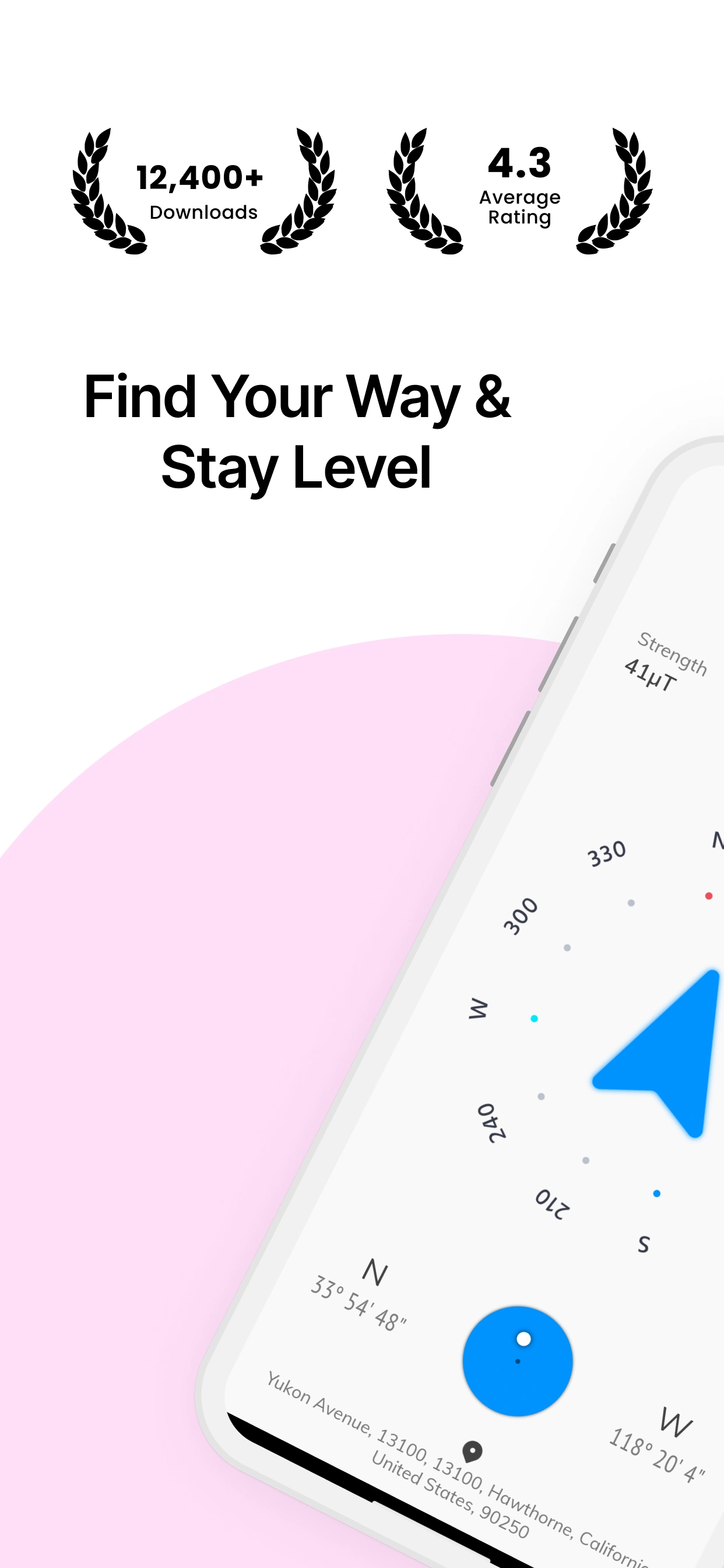
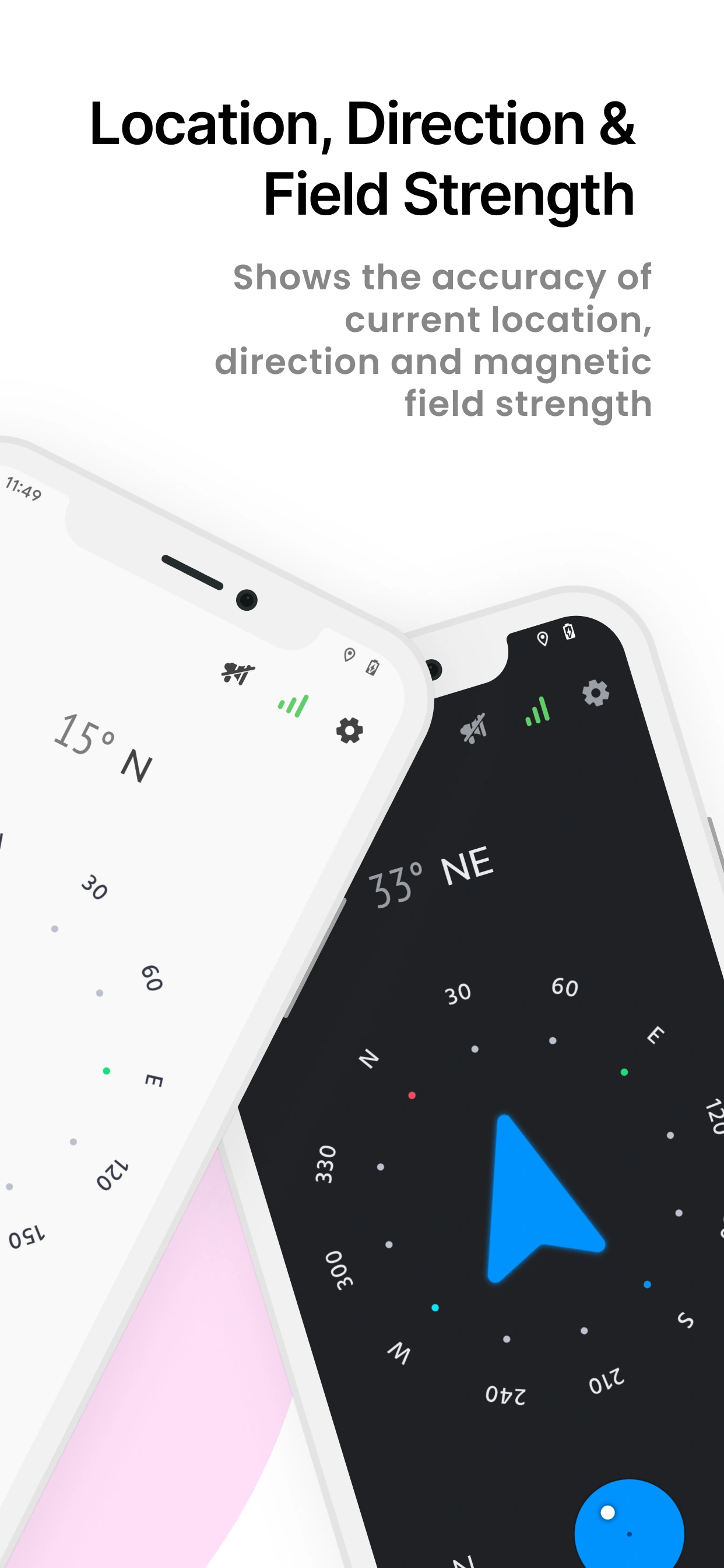
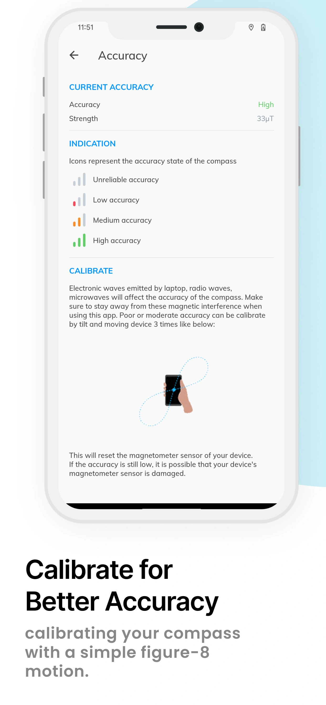
With over 12,400 downloads and a stellar 4.5-star rating, our app delivers precision navigation and measurement tools trusted by hikers, travelers, contractors, and outdoor enthusiasts worldwide. Features include magnetic compass with degree readings, real-time sensor accuracy display, magnetic field strength measurement, dual-axis spirit level for surface checking, GPS location with latitude/longitude/address, altitude above sea level tracking, speed monitoring, and beautiful dark mode for night navigation—all completely free and ad-supported. Whether you're finding your way in the wilderness, leveling picture frames, or checking construction angles, this comprehensive tool has you covered.

Left Leaf
12,400+
Downloads
Right Leaf

Why You Need Compass: Navigation & Level

In our GPS-dependent world, having reliable backup navigation is essential. Whether you're hiking remote trails where cell service fails, working on construction projects requiring precise measurements, or exploring new cities and need quick orientation, this app provides professional-grade tools without internet dependency. Perfect for outdoor adventurers needing direction guidance, DIY enthusiasts checking surface levels, travelers exploring unfamiliar territories, photographers finding optimal shooting angles, and anyone valuing self-sufficiency with accurate navigation and measurement capabilities always at their fingertips.

MAIN FEATURES
  • Sensor Accuracy: Displays the accuracy of navigation of the device’s sensors.
  • Magnetic Field Strength: Shows the strength of the magnetic field in the area.
  • Spirit Level: Checks the level of a surface or slope using a spirit level.
  • Altitude: Shows the altitude above sea level.
  • Location Accuracy: Shows the accuracy of the current location with latitude, longitude, and address.
  • Automatic Backups: Schedule regular backups to ensure your data stays protected without manual effort.
  • Dark Mode & Material Design: Offers a smooth navigation experience with a clean, modern UI and dark mode for comfortable viewing.
App Screenshot 1 App Screenshot 2 App Screenshot 3 App Screenshot 4

Getting Started with Compass

Using the Compass for Direction

  1. Open the app and grant location permission when prompted
  2. Hold your device flat parallel to the ground
  3. Watch the compass needle point to magnetic North
  4. Read the degree heading displayed at the top (0° = North, 90° = East, 180° = South, 270° = West)
  5. Check sensor accuracy indicator (High/Medium/Low)
  6. Rotate your device slowly to find your desired direction
  7. Note magnetic field strength for reliable readings

Understanding the Bubble Level

The circular bubble level is always visible on the compass screen—no need to switch modes:

Viewing Detailed Location Information

Tap the location area on the main screen to open the location details dialog:

Understanding Sensor Accuracy

The app displays real-time sensor accuracy status. Tap the accuracy indicator icon on the main screen to view detailed accuracy information:

Earth's normal magnetic field (25-65 μT) will show as high accuracy. Always check these indicators before critical navigation.

Calibrating the Compass

If compass readings seem inaccurate, calibrate by moving your device in a figure-8 pattern several times. This recalibrates the magnetometer sensor:

App Settings & Features

Access additional features and settings from the Settings menu:

When You Need Compass & Level

Hiking & Camping Navigation

Navigate trails when GPS fails or batteries die. Use the compass to maintain heading on unmarked paths. Check altitude to track elevation gain. Essential backup for wilderness adventures where cell service is unavailable.

Construction & Home Improvement

Level shelves, picture frames, and furniture instantly. Check floor and wall angles before installation. Verify deck slopes and drainage angles. Professional contractors and DIY enthusiasts rely on the spirit level for accurate measurements.

Travel & Exploration

Orient yourself in unfamiliar cities and foreign countries. Find cardinal directions when exploring new neighborhoods. Useful for understanding map layouts and planning routes without relying solely on digital maps.

Photography & Videography

Find optimal shooting angles based on sun direction. Level your camera for perfect horizon shots. Track locations of great shooting spots with GPS coordinates. Plan golden hour photography using compass directions.

Marine & Aviation Activities

Backup navigation for boating and sailing when primary instruments fail. Verify heading accuracy during flight planning. Useful for paragliding, drone flying, and other aviation hobbies requiring directional awareness.

Feng Shui & Interior Design

Determine room directions for Feng Shui arrangements. Position furniture and décor according to cardinal directions. Verify building orientations and window directions for design planning and energy flow optimization.

Pro Tips & Best Practices

Frequently Asked Questions

Hold your device and move it in a figure-8 pattern (infinity symbol) several times in the air. This recalibrates the magnetometer sensor. Do this outdoors away from metal objects and electronics for best results. The sensor accuracy indicator will improve to "High" when properly calibrated.
Magnetic interference is the main factor. Metal objects, electronics, speakers, power lines, and magnetic phone cases can distort readings. Indoor use near steel structures affects accuracy. Always check the magnetic field strength indicator—green (25-65 μT) is optimal. Low sensor accuracy requires recalibration.
Yes! The compass uses your device's magnetometer sensor and works completely offline without internet or GPS. However, GPS is required for location coordinates, altitude, and speed features. The compass and level functions work anywhere, anytime.
No, the app is very lightweight and battery-efficient. It only uses sensors when active and doesn't run background processes. GPS features consume more power, but compass and level functions use minimal battery. Dark mode further reduces battery consumption.
The compass function relies on your device's magnetometer (magnetic sensor) to detect Earth's magnetic field and determine direction. Most modern smartphones have this sensor. If your device lacks a magnetometer, the compass won't work, but level and GPS features will still function.
The level uses your device's accelerometer and gyroscope sensors, providing accuracy within 1-2 degrees for most smartphones. While not as precise as professional bubble levels, it's sufficient for hanging pictures, leveling furniture, and general DIY projects. Place device directly on the surface for best results.
Location permission enables GPS features: displaying your coordinates (latitude/longitude), current address, altitude above sea level, and movement speed. The compass and level work without location permission. We never collect or share your location data—it's only used within the app.
Magnetic North is where the compass needle points (Earth's magnetic pole). True North is the geographic North Pole. The difference is called magnetic declination and varies by location (0-20° typically). For critical navigation, look up your region's declination and adjust compass readings accordingly.

System Requirements & Compatibility

Android Version

Android 6.0 (Marshmallow) and above

Storage Space

Minimal: 3-5 MB app size

Required Sensors

• Magnetometer (magnetic sensor) - Required for compass functionality
• Accelerometer - Required for bubble level and tilt detection

Optional Sensors

• GPS - Optional, enables location features (coordinates, altitude, address, speed)

Internet Connection

Optional - Core features work completely offline
• Offline: Compass, bubble level, GPS coordinates, altitude
• Online: Address geocoding, ads, in-app purchases

⚠️ Important Note: If your device lacks a magnetometer sensor, the compass will not function, but you'll be notified upon launch. GPS works via satellites and doesn't require internet.

Supported Devices: Works on all Android smartphones and tablets with magnetic sensor support. Compatible with Samsung, Xiaomi, OnePlus, Google Pixel, Motorola, Oppo, Vivo, Realme, Nokia, and all other manufacturers. Some budget devices may lack magnetometer—check device specs.

Permissions Required: Location (optional, for GPS coordinates/altitude). No other permissions needed. Fully functional offline for compass and level features.

What our users says